Powys – The Land of Song

Powys is a county that straddles history. From the earliest occupation by settlers in the Bronze Age, through the Roman occupation and the Kingdom of Powys in the 6th century to the amalgamation in the 70s of the old counties of Radnorshire, Montgomeryshire and Brecknockshire into one, the name Powys has come full circle. The largest county in modern Wales, with the smallest population, Powys extends from Snowdonia to the Brecon Beacons and east to the ancient Marches on the borders of Shropshire and Herefordshire.
Through tiny villages and bustling market towns the visitor to Powys can in one moment be among fields and rolling hills dotted with sheep, the next on wild and windswept moorland or beside rippling lakes and reservoirs (the waters of Wales are fed to Birmingham as well as Cardiff, Swansea and Liverpool.) Quiet open roads will take you to vantage points from which to contemplate exquisite views, to picnic, to take photographs, to walk a little and then to make a slow return home, having seen how close to civilization one can be and yet so far. Our tours cater for all tastes and moods but every one will leave you with memories to cherish.
Here are our current tours:
The Elan Valley Tour
TOUR ONE
The Elan Valley Tour
This is the tour that gave birth to the idea for TriCounty Tours.
Our primary meeting point for tours will be Knighton for a pre-arranged time. However, the meeting point will be mindful of where you are staying and accessibility.
The Elan Valley sits west of the market town of Rhayader. Our route there will include valleys, hills and commons over which kites and buzzards fly high and kestrels hover in search of an unsuspecting mouse.
Traveling toward Rhayader are further displays of beautiful scenery in Radnorshire plus a peek at an open sections of the Birmingham pipeline near Nantmel. In many sections the pipe is big enough through which to drive a car.
In Rhayader the centre of the town is dominated by the historic clock tower, many examples of which are found in various market towns in the area, including Knighton. Rhayader has a collection of good eateries and a bike hire place for those who wish to enjoy a gentler pace whilst getting some exercise.
From there we travel further out on the dams road where our first port of call is the Elan Valley Visitor’s Centre, sitting in the shadow of the first dam, Caban Coch. At the centre are eating facilities plus a small shop and a desk manned by staff eager to answer questions. The Centre is another good launch place for walks and cycle rides. Access to two dams can only be done on foot due to the location, the Nant y Gro (part demolished) and the Dolymynach (unfinished). The Elan Valley estate is run by Welsh Water / Dwr Cymru.
We then continue in to the dams scheme passing the top of the Caban Coch and continuing to the next, Garreg Ddu.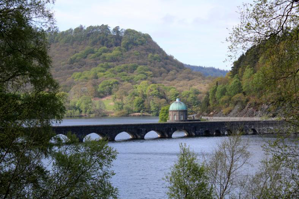 This dam is referred to as the submerged dam and it is rarely seen unless there has been something of a drought. Over the top is a road-carrying bridge which leads us on to the youngest but biggest of the dams in the Elan Valley Scheme.
The narrow valley follows the River Claerwen that comes from the dam and empties into the Caban Coch reservoir. The Claerwen dam can be viewed from below and above. It has a dark and brooding sense yet it is probably the most peaceful of the five dams.
We return back down the same road to the Garreg Ddu, crossing the dam before turning left to continue toward the Penygarreg dam, encountering waterfalls, wildlife and humpback bridges along the way. Penygarreg is the only dam that allows entrance to the public and these occur on open days throughout the year. A small entrance fee is payable and the money goes to Water Aid. Weddings have taken place on the dam since 2014.
We proceed next to Craig Coch, the top dam, the biggest of the four in the Elan Valley (not the Claerwen). Again, a road crosses the dam so that views can be taken from either side of the valley. The reservoir behind the Craig Coch is fed directly by the River Elan which begins its life a few miles west of the scheme, close to the beginning of the River Ystwyth that flows into the sea at Aberystwyth. Although this is the last dam it is not the end of the tour.
We continue on to meet with the mountain road that runs between Rhayader and Aberystwyth, which includes many beautiful viewpoints, looking forward and looking back.
We return to Rhayader and to Gigrin Farm, home to one of the first kite feeding stations in the UK. The Red Kite is now the symbol for Powys County Council. Feeding takes place at 1400 hrs GMT and 1500 hrs BST as Kites do not know that we change the clocks between the seasons. A small shop sells a few souvenirs and a warm cuppa for the times when kite viewing is a little chilly.
PRICES (per person)
1 – 5 people: £49 6 – 8 people: £45
(Includes entrance to Gigrin Red Kite feeding station. If you make an advance booking, we may be able to arrange a visit with a Ranger through the Penygarreg Dam. There will be a small extra charge for this opportunity.)
The Llyn Brianne Tour
TOUR TWO
The Llyn Brianne Tour
This tour destination is Llyn Brianne, the longest and biggest reservoir in Mid Wales.
Our primary meeting point for tours will be Knighton for a pre-arranged time. However, the meeting point will be mindful of where you are staying and accessibility.
We pass through the Victorian town of Llandrindod Wells before a taste of the great River Wye that shows it’s power at Builth Wells, causing flooding when it rains (even more than usual in Wales.) The countryside is undulating and picturesque in a softer way than the imposing scenery of North Wales.
We pass through Llanwrtyd Wells, the smallest town in Wales and home to various interesting (and strange) sporting events like the Man vs Horse race, the Bog Snorkeling Championships and others.
After negotiating the Sugar Loaf mountain we turn right for the southern tip of Llyn Brianne. This is the fifth largest reservoir in terms of water volume in the UK, the second largest in Wales and the biggest in Powys. The road leads up through a narrow valley passing the RSPB reserve of Gwenffrwd-Dinas.
At the southern tip of the reservoir you look up at the spillway, an outlet where the water sprays like a fountain. The spillway can be crossed on foot and during the summer months house martins swoop below catching insects just above the water. The road follows the edge of the reservoir for the most part, reaching a further viewpoint that looks down on the water toward the dam.
At the northernmost tip is the chapel of Soar y Mynydd, sometimes claimed as the remotest chapel in Wales. That road continues on to Tregaron, a market town that sits in the eastern section of Ceredigion, once a main gathering place for the drovers who herded sheep, cattle and geese to major markets in England.
Continuing north we reach the village of Pontrhydfendigaid, (pronounciation lessons will be given during the tour!) turning east to visit the historic remains of the Cistercian monastery Strata Florida. There there is also a small coffee and gift shop. The site is maintained by CADW. We begin our route back via Cwmystwyth which sits between Aberystwyth and Rhayader.
Nestled in the Ystwyth valley are the Cwm Ystwyth mines which saw silver, lead and zinc mining after the Bronze Age. The Ystwyth valley is the gateway to the Elan valley which brings us back in to Powys and, ultimately, back to our original departure point.
PRICES (per person)
1 – 5 people: £48 6 – 8 people: £44
(Includes entrance to Strata Florida.)

